
CodingSoftware & developer tools
Simon Willison releases datasette-maplibre 0.1a0, a Datasette map plugin built mostly from one Claude Fable 5.2 prompt
Simon Willison has released an alpha MapLibre-based mapping plugin for Datasette. Most of it came from a single prompt asking Claude Fable 5.2 to combine two existing plugins creatively. It shows clusters, heatmaps and GeoJSON on OpenFreeMap tiles, which need no API key.
From the Simon Willison article of November 15, 2026 and cited sources: Most of the plugin came from one prompt asking Claude Fable 5.2 to merge two existing working plugins and to be creative. [1] [6]
SOURCES[1] Simon Willison's Weblog: Release datasette-maplibre 0.1a0 simonwillison.net[6] GitHub: datasette-maplibre README github.com
 AT Pulse research deskPublished · Updated · 4 min read · AI-assisted analysis
AI-assisted, not human-edited. Methodology Corrections Who owns this site
- What happened
- Most of the plugin came from one prompt asking Claude Fable 5.2 to merge two existing working plugins and to be creative. [1] [6]
- Original source
- Simon Willison article, independent perspective
- Brief by
- AT Pulse research desk AI-assisted; publisher and contact on the desk page
- When
- November 15, 2026 article published
- Covered
- Nov 16 edition
- Evidence
- 10 sources across 7 sites
- 1Simon Willison's Weblog: Release datasette-maplibre 0.1a0simonwillison.net
- 2GitHub release 0.1a0github.com
- 3Claude Platform Docs: Claude Fable 5.2platform.claude.com
- 4MacRumors: Anthropic Launches Claude Fable 5.2 and Mythos…macrumors.com
- 5PyPI: datasette-maplibrepypi.org
- 6GitHub: datasette-maplibre READMEgithub.com
Reach: not measured yet
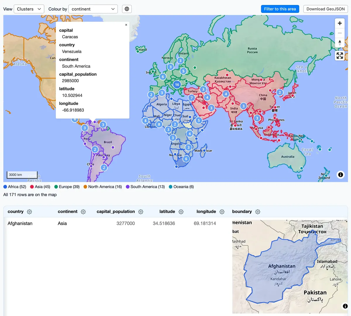
Most of the plugin came from one prompt asking Claude Fable 5.2 to merge two existing working plugins and to be creative. The model added features nobody asked for. One is a lightweight SVG preview for each GeoJSON cell that swaps in a full WebGL map only when the cell scrolls into view, which limits how many WebGL contexts run at once. [1] [6]
The plugin finds latitude and longitude columns using the same naming patterns as datasette-cluster-map, so existing databases should map without extra configuration. It can show clustered points, individual points or heatmaps, colour-code points by a column, switch between globe and 3D tilted views, and export results as GeoJSON. Map tiles come from OpenFreeMap, which needs no API key. [6] [7] [8]
The plugin is documented and has a working in-browser demo. It suggests that giving a model two working reference implementations and room to be creative can produce useful features nobody specified.
Read the full assessment
One plugin build says nothing about how the model performs in general.
Executive brief
Simon Willison released datasette-maplibre 0.1a0, a new map plugin for Datasette, the open-source tool for publishing and exploring data. According to his post, most of it came from a single prompt to Claude Fable 5.2, Anthropic's newest model at the time. The prompt asked the model to merge two existing plugins and to "be creative," and the model added features nobody had requested. The plugin draws vector maps from OpenFreeMap, a tile service that needs no API key. No independent reviews or outside coverage of the plugin turned up. It is an alpha release with minimal release notes.
What changed and event timeline
Anthropic ships Claude Fable 5.2
Anthropic released it as
claude-fable-5-2for long-running agentic work, priced at $8/$40 per million input/output tokens (;).Alpha tagged on GitHub
Willison tagged release 0.1a0, marked as a pre-release. Its only release note reads "Initial alpha release" ().
Announcement with a live demo
Willison published the one-prompt origin story and a demo that runs entirely in the browser through Datasette Lite, which uses Pyodide and WebAssembly ().
Package appears on PyPI
PyPI dates 0.1a0 to November 16. The gap from the blog post is most likely the UTC date rollover, which is an inference ().
Capabilities and access
- Requires Python ≥3.11 and Datasette 1.0a43 or later (PyPI).
- What it maps: latitude/longitude columns and GeoJSON, shown as clusters, individual points or heatmaps. Points can be colour-coded by a column.
- Bundled library: MapLibre GL JS 6.17.0. License is Apache 2.0.
Read the full section
- Install:
datasette install datasette-maplibre. Requires Python ≥3.11 and Datasette 1.0a43 or later (PyPI). - What it maps: latitude/longitude columns and GeoJSON, shown as clusters, individual points or heatmaps. Points can be colour-coded by a column. It can switch between globe and flat views, tilt in 3D, load all rows, and download results as GeoJSON. Up to 8 GeoJSON cells can show interactive maps at once (README).
- Bundled library: MapLibre GL JS 6.17.0. License is Apache 2.0.
- Model used to build it: Claude Fable 5.2 (
claude-fable-5-2): 1M-token context, 128K max output (docs).
Technical analysis for researchers and developers
- How columns are detected: it uses the same naming patterns as datasette-cluster-map:
latitude/longitude,lat/lng,lon/longand*_latitude. - Rendering performance: GeoJSON cells first show lightweight SVG previews. A full WebGL map loads only when a cell scrolls into view.
- Map data source: styles, tiles and fonts load from
tiles.openfreemap.orgby default. This can be changed in the configuration.
Read the full section
- How columns are detected: it uses the same naming patterns as datasette-cluster-map:
latitude/longitude,lat/lng,lon/longand*_latitude. Existing databases should therefore map without extra configuration (README). - Rendering performance: GeoJSON cells first show lightweight SVG previews. A full WebGL map loads only when a cell scrolls into view. Willison said this was his favourite idea the model came up with (post). The design limits how many WebGL contexts run at once.
- Map data source: styles, tiles and fonts load from
tiles.openfreemap.orgby default. This can be changed in the configuration. - Reproducibility: the full prompt is published. However, it points to a local file (
~/dev/tools/openfreemap-demo.html), so others cannot rerun it exactly.
Claims and evidence
- This is the author's own account. No session log or diff breakdown has been published (post).
- Feature list: documented in the README and testable in the Datasette Lite demo.
- Fable 5.2 coding benchmark lead: Anthropic says Fable 5.2 scores 49.1% on FrontierCode 2.0, ahead of Opus 5.5 at 45.5% (MacRumors).
Read the full section
- "Built mostly with a single prompt." This is the author's own account. No session log or diff breakdown has been published (post).
- Feature list: documented in the README and testable in the Datasette Lite demo.
- Fable 5.2 coding benchmark lead: Anthropic says Fable 5.2 scores 49.1% on FrontierCode 2.0, ahead of Opus 5.5 at 45.5% (MacRumors). These are Anthropic's own figures, and one plugin build does not test them.
- OpenFreeMap terms: the operator states there are no view limits, no API keys and no cookies (OpenFreeMap).
Context and prior work
- Datasette's earlier map plugins are built on Leaflet: datasette-cluster-map (marker clustering) and datasette-leaflet.
- OpenFreeMap was created by Zsolt Ero after nine years running MapHub's tile infrastructure.
- Datasette Lite installs pure-Python plugins from a
?install=URL parameter, which is how the zero-install demo works.
Read the full section
- Datasette's earlier map plugins are built on Leaflet: datasette-cluster-map (marker clustering) and datasette-leaflet. Willison calls this the first new Datasette geospatial plugin "in quite a while."
- OpenFreeMap was created by Zsolt Ero after nine years running MapHub's tile infrastructure. It serves its tiles with nginx from a Btrfs filesystem holding about 300 million hard-linked files.
- Datasette Lite installs pure-Python plugins from a
?install=URL parameter, which is how the zero-install demo works.
Limitations, safety and contested findings
- The release is labelled alpha, and PyPI warns it may not be stable enough for production (PyPI).
- By default the plugin depends on one community-funded tile service. OpenFreeMap says it relies on sponsorships to cover bandwidth (OpenFreeMap).
- Fable 5.2 requires 30-day data retention and is not available under zero data retention unless Anthropic authorises it.
Read the full section
- The release is labelled alpha, and PyPI warns it may not be stable enough for production (PyPI).
- By default the plugin depends on one community-funded tile service. OpenFreeMap says it relies on sponsorships to cover bandwidth (OpenFreeMap).
- Fable 5.2 requires 30-day data retention and is not available under zero data retention unless Anthropic authorises it. That matters for building on sensitive code (docs).
Business and practitioner implications
- Prompting pattern worth copying: point the model at two working reference implementations, ask it to combine them, and give it explicit room to be creative.
- Cost: mapping with MapLibre and OpenFreeMap needs no keys or per-view fees, so teams can publish geospatial data internally with almost no setup.
- Due diligence: if the plugin becomes critical, self-host the tiles or pin a style URL you control. Treat 0.1a0 as an evaluation build.
Read the full section
- Prompting pattern worth copying: point the model at two working reference implementations, ask it to combine them, and give it explicit room to be creative. Here, that cheaply produced useful features that were never specified.
- Cost: mapping with MapLibre and OpenFreeMap needs no keys or per-view fees, so teams can publish geospatial data internally with almost no setup.
- Due diligence: if the plugin becomes critical, self-host the tiles or pin a style URL you control. Treat 0.1a0 as an evaluation build.